 |
Name Eire, Erin, Ireland,
Ulster, the Esmerald Isle, Northern Ireland, the Irish State, Free Ireland, The United
Kingdom of Great Britain and Northern Ireland. If you are not Irish or British, all these
names can be confusing. The island of Ireland is also called the Esmerald Isle, because of
its beautiful green countryside. The poetic name for the island is Erin. Gaelic is the
original language of Ireland and the Gaelic name for Ireland is Eire. |
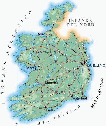
| Location Ireland (Éire)
is located in far Western Europe, in the North Atlantic Ocean, and separated from Great
Britain by Saint George's Channel on the south-east, the Irish Sea on the east, and the
North Channel on the north-east. Politically, the island is divided into Northern Ireland,
a constituent part of Great Britain, and the Republic of Ireland, formerly Eire. The
island is divided into four historical provinces - Connaught (Connacht), Leinster,
Munster, and Ulster - and administrative units called counties. The Republic of Ireland
consists of Connaught, Leinster, and Munster provinces, totaling 23 counties, and in the
north, 3 counties of Ulster Province. Northern Ireland consists of 26 districts, the
remainder of Ulster Province. The area of the island is 84,431 sq km (32,599 sq mi)
(Republic of Ireland, 70,283 sq km/27,136 sq mi; Northern Ireland, 14,148 sq km/5463 sq
mi).
In a northern and southern direction, the maximum length of
Ireland is 486 km (302 mi); its extreme width is 280 km (174 mi). Malin Head, at latitude
55º 27' north, and Mizen Head, at latitude 51º 27' north, are, respectively, the
northernmost and southernmost points on the island; easternmost and westernmost points are
demarcated by longitude 5º 25' west and longitude 10º 30' west.
|